A GPS tracker can reply to a text message and still show offline. A simulator can display 4,000 configured devices but zero active connections. And a route can look correct on a map while its timestamps or reported distance are wrong.
These are different problems. They need different tools.
This field guide covers nine free Open VTS GPS tracking utilities, using their actual interfaces. Whether you install trackers, support a fleet, develop telematics software, or run a GPS tracking company, you can find a problem, follow a few steps, and know what evidence to check next.
Find your starting point:
- Tracker offline or not configured? Start with Find APN → GPS Tracker Command Generator → GPS Device Diagnostic → Identify GPS Device Protocol.
- Need to test a platform without thousands of vehicles? Use Virtual GPS Device Farm. For route records without real customer journeys, use Create Fake Route Driven Data.
- Investigating a location or mileage complaint? Use Latitude & Longitude Info → Find Route → Display Map Data Points.
All nine tools are linked below, or explore the Open VTS Free Tools directory.
1. Find APN
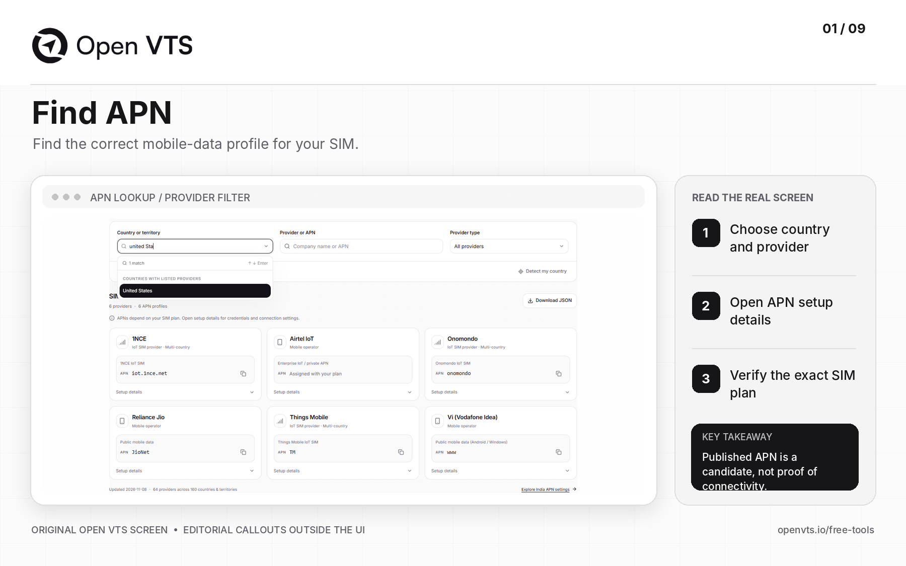
Find IoT SIM and APN Provider is a free GPS tracker APN lookup tool for installers and support teams. Search by country, mobile operator, or IoT SIM provider to find published access point names and available connection details. An APN tells a cellular tracker which mobile-data network profile to use; it is different from the tracking server IP and port. Getting the APN right is one of the first steps in fixing a GPS tracker that responds to SMS but never sends location data.
Why you need?
- The device replies to SMS but remains offline. SMS can work even when mobile packet data is not configured.
- You changed SIM suppliers. The old operator's APN may no longer apply.
- You are installing trackers internationally. IoT roaming, radio coverage, and permitted networks can differ by country and plan.
- Your customer uses a private or enterprise APN. A public APN found online may be incorrect for that specific subscription.
How to use?
- 1Open Find IoT SIM and APN Provider.
- 2Select the country or territory, then search the actual SIM provider. Use the provider-type filter if needed.
- 3Open Setup details and check the APN, username/password requirements, authentication, IP type, and provider notes.
- 4Confirm the settings against the specific SIM plan; configure one test tracker, not the whole fleet.
- 5Check whether that tracker establishes mobile-data connectivity and attempts to reach your GPS listener.
Practical example: a business replaces SIMs in 75 vehicles. Prove the APN and data connection on one unit, record the working profile, and only then repeat the configuration across the others.
Result check: an APN listing is a starting point, not evidence that the SIM has coverage or that the GPS server is reachable.
2. GPS Tracker Command Generator
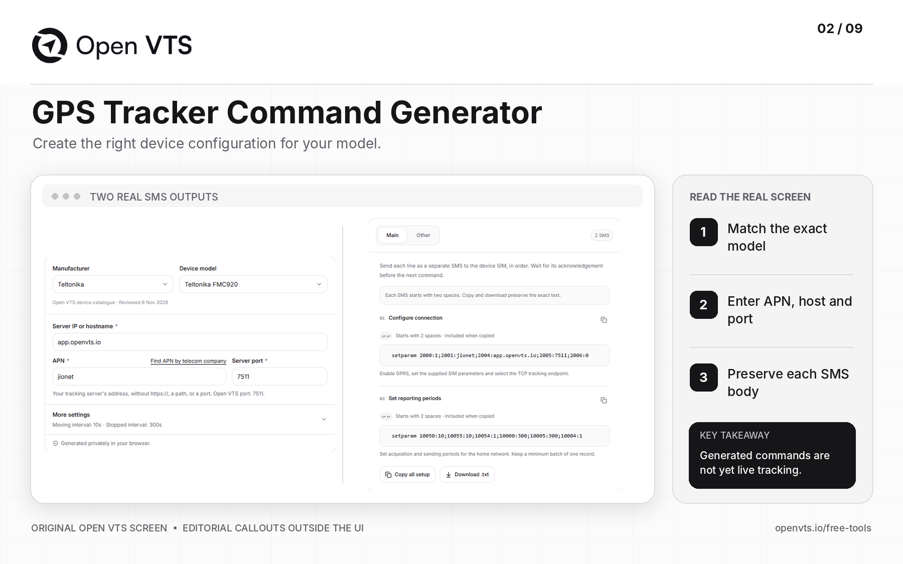
The GPS Tracker Command Generator converts your device settings into manufacturer- and model-specific configuration commands for supported GPS trackers. Enter the APN, reachable tracking server hostname or IP, listener port, and reporting settings. The utility prepares exact command text, including formatting that can be easy to lose when copying SMS instructions manually. It supports the documented profiles shown in its device selector; it does not remotely configure the tracker or send SMS itself.
Why you need?
- You have the server details but not the correct SMS syntax. Different models may use different separators, commands, or credential rules.
- The tracker points to an old platform. The endpoint must be changed to the new server and listener port.
- Locations arrive too often or too rarely. Supported reporting intervals need to be set correctly.
- A command is rejected after copying. Some profiles rely on exact spaces, punctuation, or message order.
How to use?
- 1Open the GPS Tracker Command Generator.
- 2Select the exact manufacturer and device model. Read any profile or firmware compatibility notice.
- 3Enter the APN, reachable server address, and matching listener port. Use your own deployment details—not the values in an example screenshot.
- 4Select Generate commands. Review the Main and Other tabs and the indicated delivery method.
- 5Copy each SMS body exactly, send it by the supported authorized method, and wait for its acknowledgement before proceeding.
- 6Confirm the tracker actually connects to your server and begins reporting fresh data.
Practical example: the real screenshot shows a Teltonika FMC920 profile generating two separate SMS messages: one for the connection and another for reporting periods. It warns that the SMS bodies begin with two spaces; removing those spaces could change the command.
Result check: a generated command—or an SMS reply saying it was accepted—is not proof of live tracking. The SIM data path, server listener, device identity, and GPS fix must still work.
3. GPS Device Diagnostic
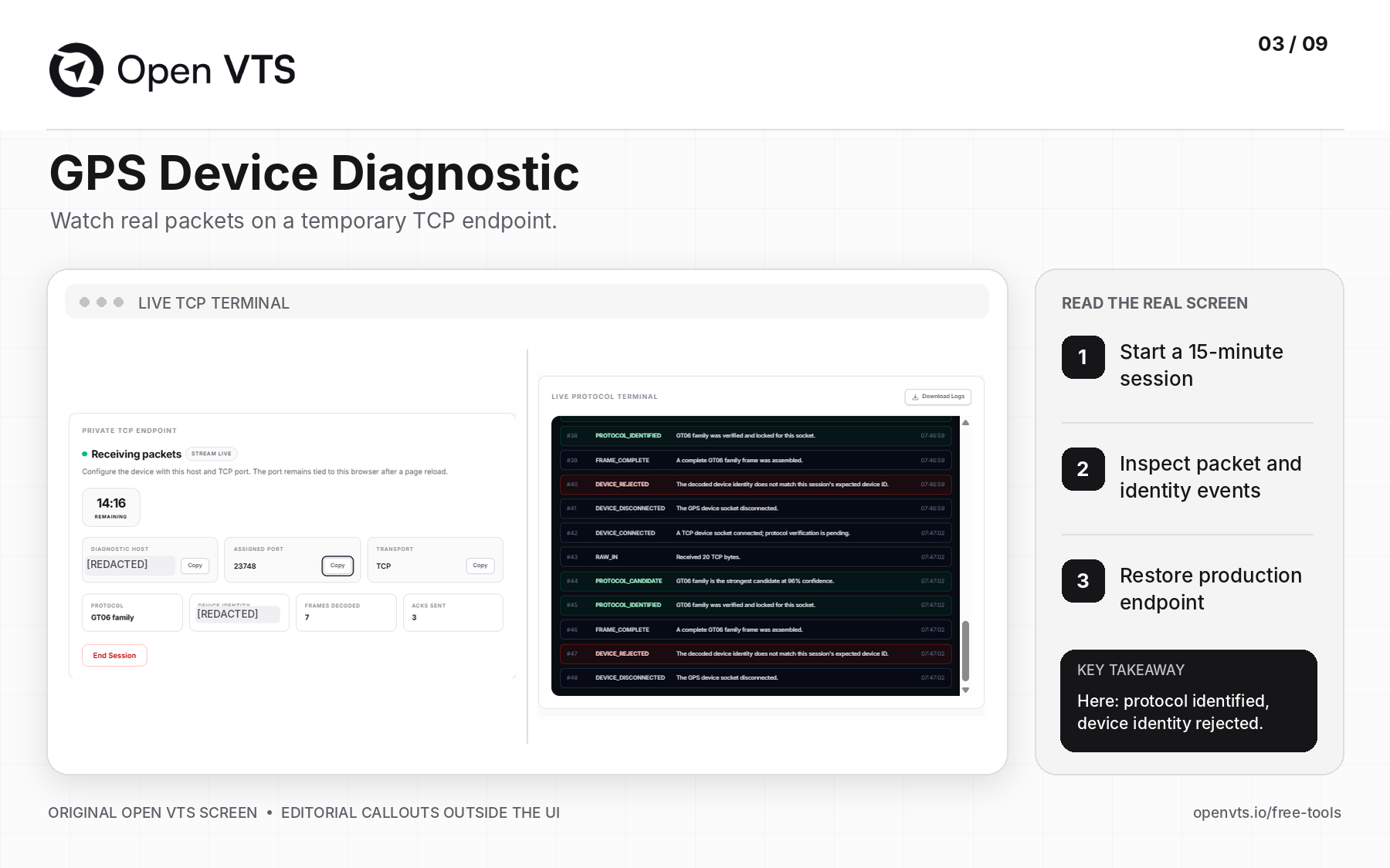
GPS Device Diagnostic gives an authorized real GPS tracker a temporary, private 15-minute TCP testing endpoint. When you point one device at its assigned host and port, the tool shows live connection, packet framing, likely protocol, device identity, and acknowledgement events. It is a focused GPS tracker online/offline troubleshooting tool: instead of assuming the problem is the software, you can inspect which part of the communication is actually succeeding.
Why you need?
- The SIM uses data but the vehicle stays offline. You need to see whether a TCP connection reaches the endpoint.
- Your listener receives bytes but not locations. Frames may be incomplete, rejected, or incorrectly decoded.
- A device appears to use a familiar protocol but is rejected. Protocol recognition and device-identity acceptance are separate checks.
- You need a clear escalation log. Real terminal events are more useful than saying “the GPS is not working.”
How to use?
- 1Save the tracker's current production server address and port so you can restore them later.
- 2Open GPS Device Diagnostic and start its temporary session.
- 3Configure one authorized tracker with the session's assigned TCP host and port.
- 4Observe the terminal: DEVICE_CONNECTED, RAW_IN, FRAME_COMPLETE, PROTOCOL_IDENTIFIED, and any DEVICE_REJECTED or ACK events.
- 5Download and redact the log if needed, then restore the original server destination and end the session.
Practical example: the supplied real screenshot shows a GT06-family protocol being identified, followed by DEVICE_REJECTED because the reported identifier did not match the session's expected identity. That means some network and decoding steps succeeded; the next investigation is identity matching, not blindly replacing the SIM.
Result check: the diagnostic receives data on its temporary endpoint, not your production server. Supported acknowledgements are limited to validated protocol traffic; not every detected packet receives an ACK.
4. Identify GPS Device Protocol
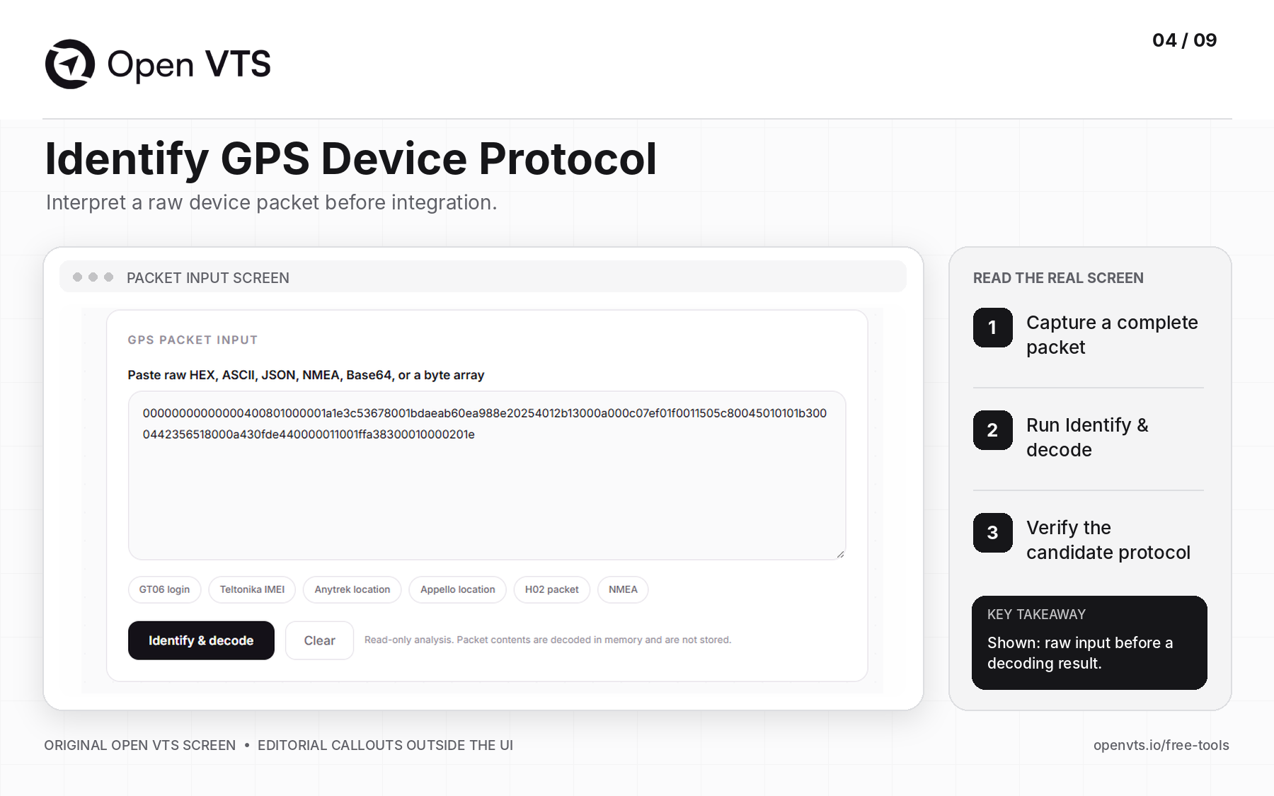
Identify GPS Device Protocol is a free online GPS protocol decoder for raw tracker messages. It accepts HEX, ASCII, JSON, NMEA, Base64, and byte-array input, compares the packet against Open VTS's published catalogue of 269 protocol-specific decoders, and explains candidate matches with available readable fields. This is useful for integrators handling unknown hardware, GT06-family devices, Teltonika packets, or GPS messages that do not match the expected listener.
Why you need?
- The hardware brand or protocol is uncertain. A sticker or reseller name may not tell you the on-wire message format.
- You have HEX packets but cannot interpret them. Raw bytes need framing and decoder context.
- A device logs in but location is missing. Different packet types contain different information.
- Firmware behaves differently from the manual. You need packet evidence to compare with documented behavior.
How to use?
- 1Capture a complete login or location packet from an authorized device or test log.
- 2Open Identify GPS Device Protocol.
- 3Paste the raw sample and select Identify & decode. The tool accepts several representations; preserve the original data.
- 4Examine the candidate protocol, framing evidence, packet type, identity, timestamp, coordinates, checksum, and sensor fields when present.
- 5Compare more than one message type with the actual hardware and firmware documentation before selecting the production listener.
Practical example: a “GT06-compatible” tracker sends a valid-looking login but no usable location. Identifying its login frame is only the first step; capture a location message to confirm coordinate decoding and timing.
Result check: one matching packet does not establish every feature or command. The provided screenshot shows the packet-input form before decoding, not a confirmed identification result.
5. Virtual GPS Device Farm
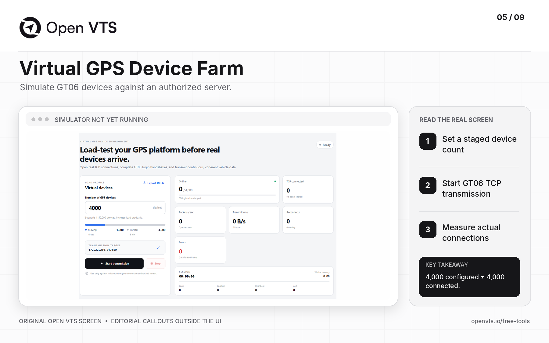
Virtual GPS Device Farm is a downloadable desktop GPS device simulator and load-testing tool. Its documented 1.0 release simulates GT06 over TCP, with independent virtual tracker connections, login/ACK handling, moving and parked reporting, and reconnect behavior. A GPS tracking software provider can exercise a staging listener before thousands of physical devices arrive, without confusing simulated traffic with a real cellular-network test.
Why you need?
- You are onboarding a large fleet. Check connection admission, packet ingestion, and live-position freshness before launch.
- You have changed your listener or backend. Reproduce login, location, heartbeat, and reconnect behavior.
- You are comparing server configurations. Count packets, errors, backlogs, and CPU/RAM under a defined workload.
- You need repeatable QA. A known population of synthetic device IDs is easier to reproduce than traffic from live fleets.
How to use?
- 1Open Virtual GPS Device Farm and download the desktop application for your supported operating system.
- 2Set up a staging server you own or are authorized to test, with the correct GT06 TCP listener.
- 3Choose a small initial device count. Export simulated IMEIs and register them in the test platform as required.
- 4Enter the server's IP and port, then choose moving/parked behavior and reporting intervals.
- 5Select Start transmission. Increase the number of devices gradually while comparing simulated Online, TCP connected, Packets/sec, and Errors with the server's accepted records and resource usage.
- 6Include reconnect/recovery checks, stop the test, and document the results.
Practical example: the actual screenshot has 4,000 devices configured: 1,000 moving every 10 seconds and 3,000 parked every 5 minutes. That configuration represents about 110 scheduled location reports per second on average, excluding login, heartbeat, and reconnect traffic. But Online = 0 and TCP connected = 0 in the screenshot: no successful load test is demonstrated yet.
Result check: measure the whole pipeline—connection acceptance, live delay, missing or duplicate data, queue growth, and recovery—not just configured device count. GT06 simulation does not prove support for every other GPS protocol.
6. Latitude & Longitude Info
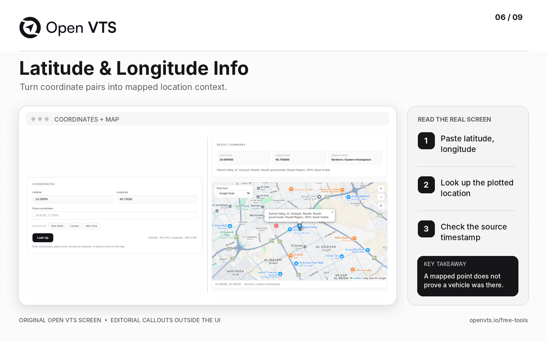
Latitude & Longitude Info is a free GPS coordinate lookup and reverse-geocoding tool. Paste a latitude/longitude pair to locate it on a map and obtain an available human-readable place description, geographic context, and coordinate formatting. Dispatch teams and telematics developers use it to check where GPS data points fall, distinguish latitude from longitude, and investigate apparent location errors without interpreting a raw CSV by eye.
Why you need?
- A customer sends coordinates instead of an address. You need to explain where the point plots.
- The pin appears in the wrong country or ocean. Latitude and longitude may be reversed or have an incorrect sign.
- A GPS integration has inconsistent coordinate formats. Check decimal degrees and hemispheres.
- Someone disputes a recorded stop location. Separate the geographic position from the reported timestamp and GPS accuracy.
How to use?
- 1Open Latitude & Longitude Info.
- 2Paste latitude, longitude into the coordinate field or enter each value separately.
- 3Check the allowed ranges: latitude −90 to +90, longitude −180 to +180.
- 4Choose Look Up and inspect the map marker, returned place details, and coordinate formats.
- 5Compare with the original GPS record's timestamp and accuracy/context before explaining it to a customer.
Practical example: the real screenshot uses 24.59916, 46.75656, which plots in the Riyadh area. The location description comes from map data and can be approximate, especially for private roads or incomplete address coverage.
Result check: the tool answers where the entered numbers point. It cannot confirm that a particular vehicle was there at a particular time.
7. Create Fake Route Driven Data
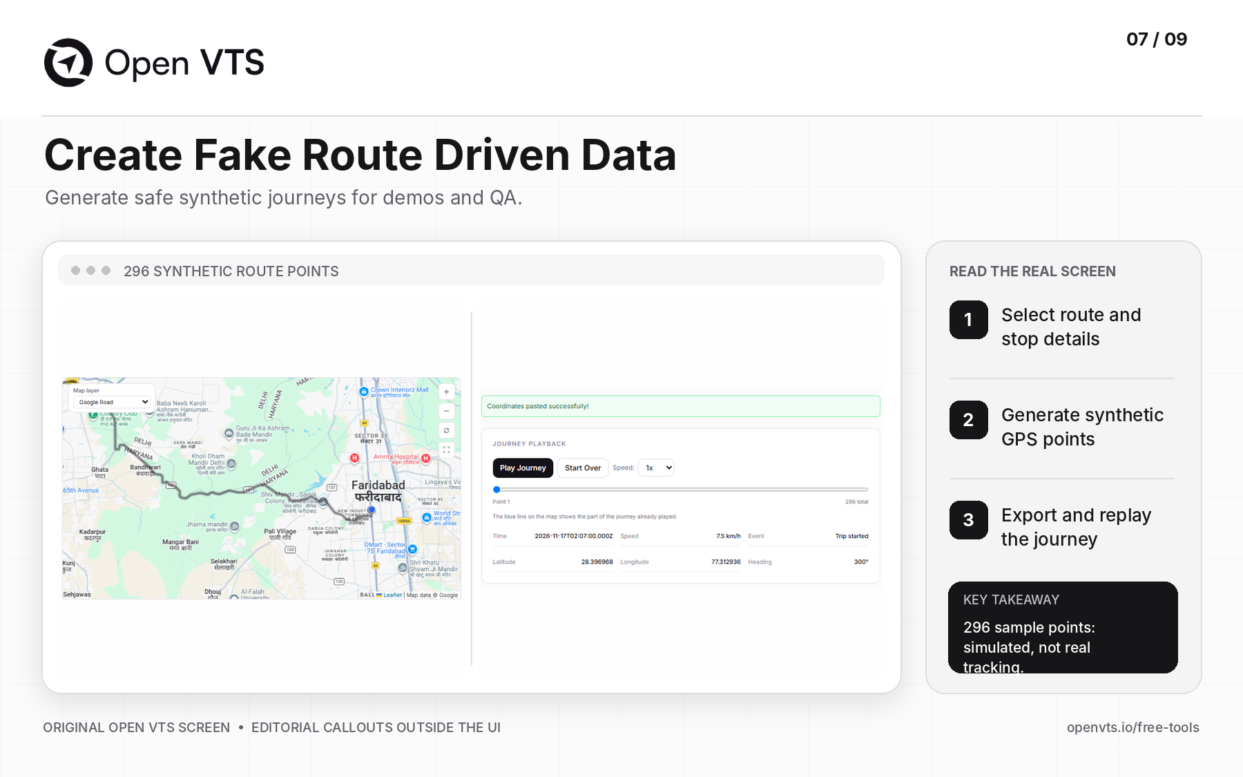
Create Fake Route Driven Data is a free synthetic GPS route generator for demos, QA testing, and trip replay. Define a journey using waypoints, starting time, speed, and stoppages; the utility follows a road route and exports timestamped GPS-like records with location, speed, heading, and movement information. It is particularly helpful when developers need meaningful sample GPS tracking data but should not expose real customer trip history.
Why you need?
- Your demo account has no useful trips. Show a plausible journey without using a real customer's route.
- You want to test a stop or trip report. Generate repeatable moving and stationary records.
- Your QA team needs CSV/GPX/KML/JSON samples. Use known data to check import and playback.
- You need to explain a route-data bug. Reproduce the same set of points independently of live hardware.
How to use?
- 1Open Create Fake Route Driven Data.
- 2Add start, destination, and optional intermediate waypoints on the map.
- 3Set the journey's starting time, speed, stop durations, and available reporting settings.
- 4Generate the route and inspect the map and Journey Playback controls.
- 5Download the desired data format, then open the exported file with Display Map Data Points to check the points and timestamps.
Practical example: the supplied screenshot shows a route with 296 synthetic points and playback controls. A software tester can use a similar journey to verify whether a delivery stop appears in a report and whether the sequence remains consistent.
Result check: these records are synthetic. They do not prove that a physical tracker sent data, and they are not real evidence of a vehicle's journey. Generating route rows is different from generating live TCP tracker traffic.
8. Find Route
Find Route is a free multi-stop GPS route planner and driving-distance calculator. Enter starting and destination coordinates, optionally include intermediate stops, and calculate a road route with distance, estimated duration, and available turn guidance. It gives dispatchers and field teams a planning reference when comparing a proposed route with a known itinerary or GPS tracking history.
Why you need?
- A delivery or service job has multiple stops. Estimate a reasonable road journey before dispatch.
- A customer questions trip mileage. Compare planned driving distance against actual recorded travel—not against a straight line.
- You are reviewing location data from a spreadsheet. Verify that waypoints map to sensible roads.
- Two mapping services return different distances. Understand that roads, restrictions, and routing assumptions can vary.
How to use?
- 1Open Find Route.
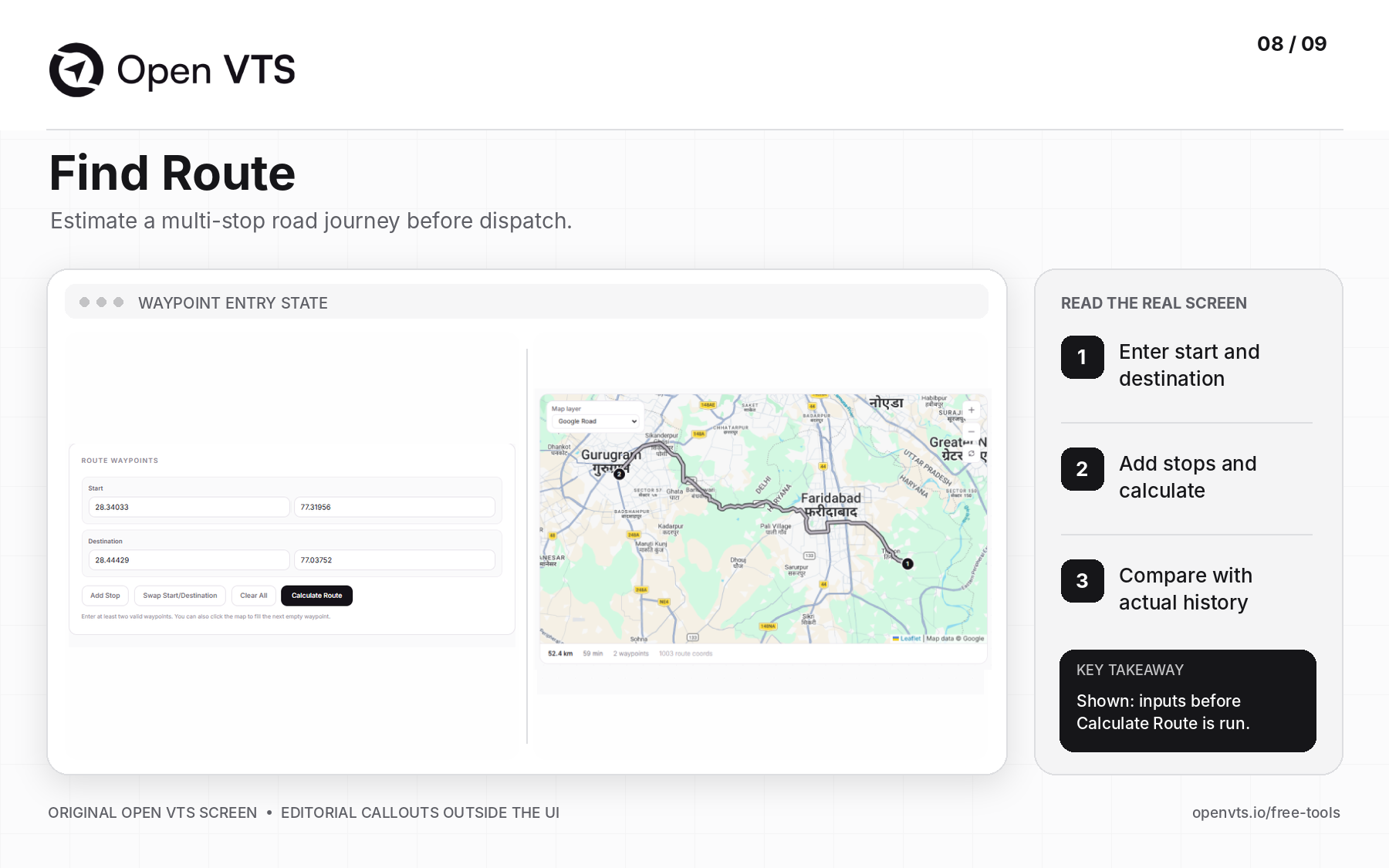
- 2Enter the start and destination coordinates, or use the map to fill an empty waypoint.
- 3Select Add Stop for required intermediate destinations and arrange them in the intended travel order.
- 4Click Calculate Route. Inspect the road geometry, estimated distance, duration, and step summary when available.
- 5Compare this planned route with actual vehicle timestamps and exported GPS points before drawing a mileage conclusion.
Practical example: a customer says a vehicle traveled farther than a dispatch estimate. Plot the intended stops first, then compare that route with the recorded journey—allowing for detours, traffic decisions, missed GPS reports, and differences in map data.
Result check: the screenshot shows the waypoint-entry screen before calculation. A planned route is not proof of where the driver actually traveled, and the tool does not replace full fleet route optimization.
9. Display Map Data Points
Display Map Data Points is a free browser-based GPS CSV-to-map visualizer that also accepts KML, GPX, and GeoJSON. It turns raw latitude and longitude records into a mapped route, supports metadata inspection and travel direction, and can replay movement when valid timestamps are available. This makes it useful for checking exported GPS tracking history, suspicious location jumps, missing rows, and disputed journeys without writing a custom mapping application.
Why you need?
- A customer disputes a trip or mileage report. Inspect the route geometry outside the reporting dashboard.
- The data export contains thousands of rows. Find invalid coordinates, duplicate timestamps, or abrupt jumps visually.
- You are integrating a new GPS device. Check whether latitude, longitude, and time fields are mapped correctly.
- A developer needs a repeatable demo. Import known synthetic data generated by the route tool.
How to use?
- 1Open Display Map Data Points.
- 2Upload a CSV, KML, GPX, or GeoJSON file you are authorized to examine.
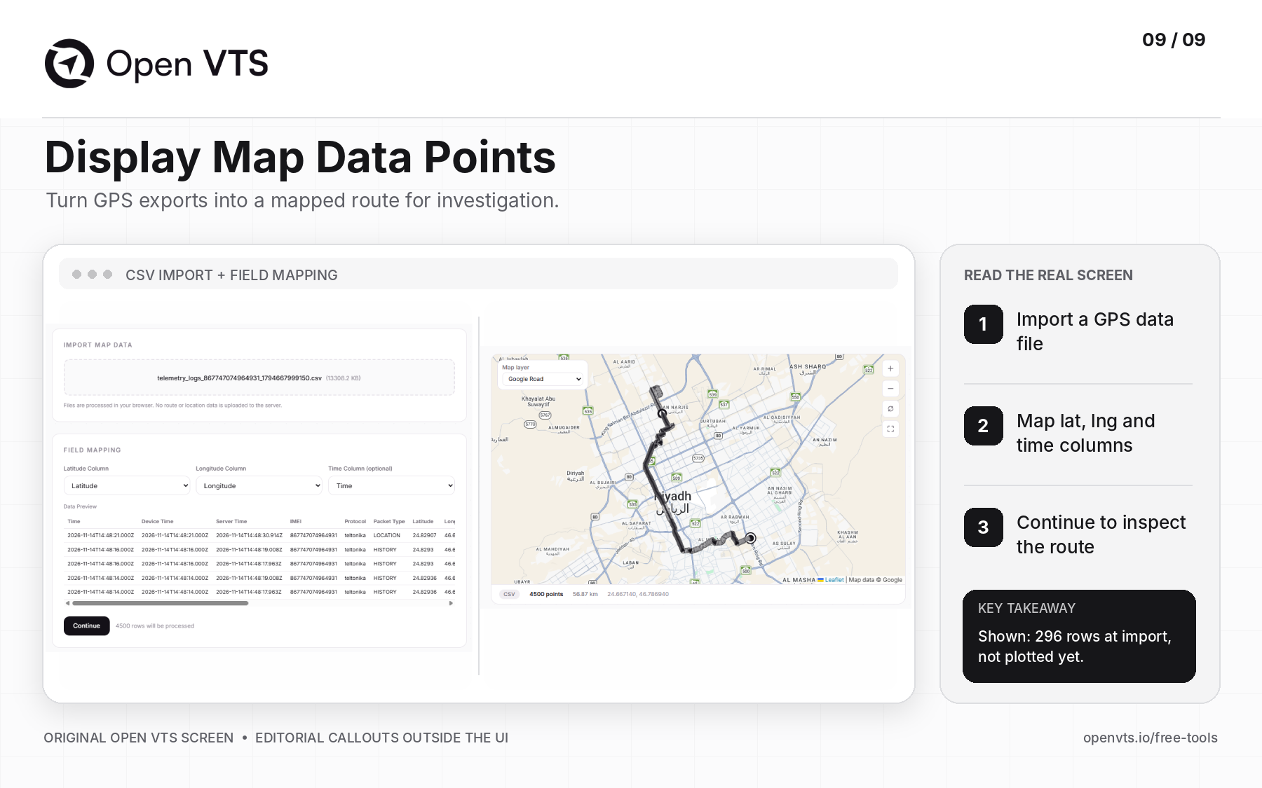
- 3For CSV, choose the correct Latitude Column, Longitude Column, and optional Time Column.
- 4Inspect the data preview and select Continue. Check that the records plot in a plausible order on the map.
- 5Use point details, direction markers, and available playback controls to review the journey. Look for invalid rows, time gaps, and implausible jumps.
- 6Compare findings with the original export and the report's distance/timestamp rules.
Practical example: the real screenshot shows a synthetic file named Demo_Vehicle_simulated_route...csv, with 296 rows available for import. Its columns include latitude, longitude, timestamp, speed, and heading. The screenshot shows file import and field mapping, not the final plotted route.
Result check: a clean-looking polyline does not automatically validate distance or sensor data. Check timestamps and source records. The documented tool processes location files in your browser rather than uploading the file to the Open VTS server.
Three real-world problem-solving workflows
A GPS tracker is offline after a SIM change:Find APN confirms the plan-specific profile → GPS Tracker Command Generator prepares the model's exact configuration → GPS Device Diagnostic checks TCP traffic → Identify GPS Device Protocol investigates unclear raw packets. Stop at the first failed handoff; do not change everything at once.
You are preparing a large fleet migration:Virtual GPS Device Farm exercises GT06 connections against an authorized staging environment. Create Fake Route Driven Data separately creates known journey records for QA. Display Map Data Points verifies the generated or exported geometry. Neither test alone replaces actual-device, real-network, and full production acceptance testing.
A customer disputes vehicle mileage:Latitude & Longitude Info verifies the reported coordinates → Find Route gives an estimated road route between the intended stops → Display Map Data Points plots the actual exported records. Explain the differences between planned distance, recorded GPS distance, and missing data before deciding what happened.
The principle worth remembering
A tool should answer one specific question—and help you decide what to test next.
A generated SMS does not prove a connection. A TCP connection does not prove that the device identity was accepted. A decoded packet does not prove accurate trip history. A simulated fleet does not establish real-world capacity until the test has run and the results have been measured. And a route on a map is not a substitute for reliable timestamps.
That is how a GPS tracking business replaces guesswork with evidence.
Explore all nine tools:Open VTS Free Tools. If you want to move from isolated diagnostics into your own live fleet platform, you can also download Open VTS and review its supported hardware and protocols.
Which problem takes your team the most time today: device configuration, protocol troubleshooting, server load testing, or trip-data disputes?
Track Without Limits, Powered by You.