
Give the journey a structure
Prepare stops and routes, organize trip schedules, and make driver and vehicle assignments.
PASSENGER TRANSPORT & SHUTTLE FLEETS
Plan passenger routes, assign trips to drivers and vehicles, follow the latest GPS position, and respond to delays from one self-hosted fleet platform. Built for airport transfers, corporate shuttles, campuses and passenger operators.
Vehicle information reflects compatible GPS hardware and reporting conditions. Passenger bookings and ticketing are separate operational systems.

TRANSPORT OPERATIONS, NOT JUST A MAP
Passenger transport has a rhythm: dispatch windows, pickup points, scheduled stops, changing traffic, different drivers and people waiting for a ride. A location marker is useful only when your team can relate it to the journey being operated.
Open VTS brings supported tracking data and trip operations together. Dispatch can compare the latest vehicle report with an assigned trip, inspect the planned path, and investigate delays or deviations without relying entirely on telephone check-ins.
Prepare stops and routes, organize trip schedules, and make driver and vehicle assignments.
Review vehicle positions, last updates and configured route events against the planned service.
Investigate delays, unscheduled stops and route deviations using location history and human review.
PASSENGER & SHUTTLE FLEET GPS TRACKING
Explore three fictional operations. Select a vehicle to see its latest reported position, scheduled service, and stop context. The real Open VTS platform shows vehicle information received from your compatible trackers.
Terminal connector
Illustrative stop and ETA data. Live tracking accuracy depends on the device, signal and configuration.
Keep the fleet view connected to the actual assigned journey, not just the vehicle ID.
Distinguish a current position from the last known point when devices or networks are unavailable.
Use trip history, route events and stopped locations to investigate service exceptions.
OPEN VTS OPERATIONS MODULE
Open VTS Operations connects route points, schedule, assignments and journey monitoring. Use the walkthrough to understand a typical shuttle service—from the first stop to the completed trip.
This diagram explains how the documented route tools and Operations capabilities fit together. All names and times are fictional.
Create a scheduled service and define its pickup points and destination.
A route plan is not a vehicle assignment.
Prepare repeated commute or campus journeys through the relevant scheduling workflow. Confirm that dates, routes and assignments are current before dispatch.
Use the route optimizer to review stop order and paths. Rider constraints, accessibility, time windows and service policies still need operational review.
Assign the appropriate driver and vehicle separately from building the location-based route; then monitor its execution.
ETA, ROUTE ADHERENCE & EXCEPTION HANDLING
A scheduled stop time and a current ETA are not interchangeable. Compare a normal trip, a traffic delay and a stale tracker update to see how different the dispatcher’s decision should be.
A recently reporting vehicle is approaching the next stop along its expected route.
Continue monitoring. Make passenger-facing updates only through authorized channels and verified data.
Times, status and progress are illustrative—not a live ETA service. Predictions depend on available routing, traffic and current GPS data.
Inspect the reported path against the assigned journey before assuming an unsafe or unauthorized detour.
Use a configured boundary or recorded stop to help understand depot, terminal or pickup-area activity.
Escalate to the right team using the last known position—not a false “live” marker.
VEHICLE GPS vs PASSENGER INFORMATION
A shuttle arriving near a stop does not establish who boarded. A predicted arrival time does not prove the passenger was notified. Tickets, capacity counts, accessibility requests, and boarding records may live in other systems.
Build a more complete passenger experience by connecting these records deliberately, while keeping location access proportionate to each audience.
Use the latest position, historical travel, stops, and supported route and geofence events. This establishes movement context but does not identify who was riding.
INSIDE OPEN VTS
Explore genuine Open VTS interface references for tracking, routes, geofences and reports. The industry-specific shuttle examples elsewhere on this page are explanatory illustrations, not screenshots of a dedicated passenger app.
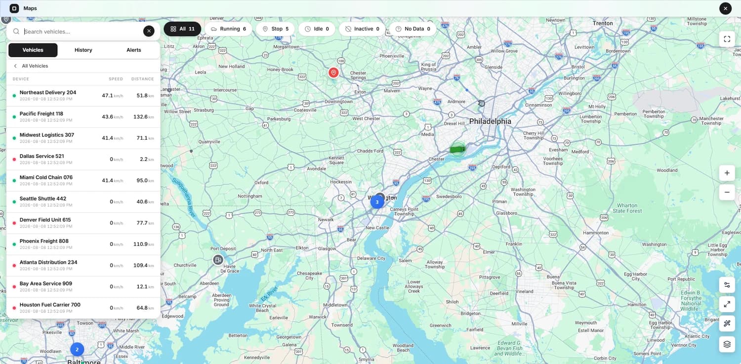
The actual tracking screen provides vehicle-position context. Shuttle schedule and rider-information records should be configured or integrated according to your operation.

Dispatch teams need the next useful action, not more screens. The right visual hierarchy is simple: identify the vehicle, check the last report, compare the trip, decide whether to intervene.
Passengers need a different view: relevant service information without exposure to other vehicles, staff, or customer accounts.
Explore the mobile applicationTRANSPORT MODELS & SERVICE TYPES
The routes change, but fleet managers still need to coordinate vehicles, drivers, locations and exceptional events.
Coordinate arrivals and departures, compare shuttle position with pickup windows, and review terminal or hotel-zone movement.
Support shift-based staff shuttles, scheduled pickup points, recurring service, and delays affecting arrival windows.
Follow recurring guest transfers between hotels, parking areas, event venues and nearby transport hubs.
Monitor internal circulators, campus shuttles and multi-building routes with separate operational access.
Review scheduled journeys, long-distance route history and stops while preserving driver and passenger privacy.
Manage a mixed passenger fleet within the same GPS workspace, using supported devices and appropriate account permissions.
OPERATIONS & ACCOUNTABILITY
Tracking records can answer useful questions, but they should be reviewed in context and never substituted for passenger safety processes.
Compare planned journeys against recorded travel, stops, deviations and updated positions.
Configure meaningful terminal, campus, depot and service-area boundaries where supported.
Use activity, history and supported reports to investigate missed services, unusual stops or operational questions.
Give fleet managers, administrators and drivers only the information appropriate to their duties and permissions.
SELF-HOSTED GPS SOFTWARE FOR PASSENGER OPERATORS
Open VTS is designed for customer-operated deployment. You decide where the platform runs, which teams access it, how supported device data is retained and which other business systems it connects with.
Use documented APIs to build links with approved booking, scheduling, passenger information, dispatch or reporting systems. Those external integrations are not automatically included as native Open VTS passenger modules.
Understand self-hosted vs SaaSOperate Open VTS on your chosen customer-controlled infrastructure. Plan security, backups, updates and monitoring.
Use the documented admin, team, user and driver permission structure to keep operational access relevant.
Integrate through documented REST interfaces. Booking, ticketing and public transit feeds require separate design and validation.
The Free software tier supports up to 50 vehicles, while larger tiers expand licensed capacity. Infrastructure and third-party services are separate costs.
FREQUENTLY ASKED QUESTIONS
Straight answers about shuttle GPS tracking, trip operations, ETA accuracy, rider data, integration and self-hosting.
Read the documentationIt is a fleet operations system that receives GPS positions from compatible vehicle devices and presents location, history, movement and supported events. In Open VTS, these records can also be used alongside planned routes and trip operations. It is different from ticketing or passenger booking software.
Yes. Compatible GPS devices fitted to shuttles, vans or buses can report their positions to the Open VTS server. A fleet manager can review position, history and supported trip or geofence information. Flight-linked passenger scheduling is a separate integration.
Open VTS Operations includes scheduling and recurring-trip concepts. Configure service dates, stops and the responsible driver and vehicle in the supported workflow, then verify the assigned trip in the live system before the scheduled run.
No. Open VTS route optimization works on locations and stop order. Vehicle and driver assignment are separate operational actions. Rider capacity, accessibility, pickup windows and service policy also need review.
Operational ETAs are estimates based on the route and available current data. Their reliability depends on GPS freshness, routing and traffic assumptions. A delayed or offline tracker should show its last known update rather than implying a live arrival prediction.
Route-deviation and geofence alerts are supported where correctly configured for the relevant journey and device reports. The dispatcher should assess the actual context before treating an event as an incident.
Open VTS can provide controlled tracking and APIs. A passenger-specific view, public tracking page or mobile integration should be scoped and tested independently to avoid exposing unrelated routes, users or vehicles.
Not from vehicle GPS alone. Accurate passenger counts or boarding confirmation require suitable passenger systems, ticket validation, RFID, sensor inputs or verified staff records and integration.
Vehicle GPS tracking is not a booking engine. Ticketing, seat inventory, fares, reservations and payment settlement require a separate passenger-management system or a custom integration.
Documented Open VTS data and APIs may be used as inputs for a separately developed feed. Native, ready-made GTFS/GTFS Realtime publication is not established by the available public product documentation; it must not be assumed without testing.
Yes, subject to compatible trackers and your licensed vehicle capacity. Roles, vehicle access, reporting and telemetry may vary by deployment, device and account configuration.
Trip history, route travel, stops, supported speed events, geofence activity and scheduled reports can support operator review. Ridership, fare collection and occupancy measures need other records.
No tracking application by itself establishes accessibility or transport compliance. Operators must assess vehicle accessibility, service policies, driver procedures and applicable local requirements separately.
The platform can only show the latest information it has received. Some trackers can buffer and resend data after coverage returns, depending on hardware and configuration. Dispatch needs a fallback communication process for service-critical journeys.
The current Free tier covers up to 50 vehicles without a software time limit and includes full platform features. GPS devices, connectivity, hosting and third-party services are separate operational expenses. Verify the latest terms on the pricing page.
Begin with one representative route. Verify GPS updates, driver assignment, stop history, route changes, exceptions and reports. Include actual dispatch staff and confirm any passenger-facing system and privacy requirements before expanding.
MOVE YOUR OPERATIONS FORWARD
Track vehicles, schedule trips and review route operations on infrastructure your organization controls. Start with a real service, validate your hardware and build outward from there.