

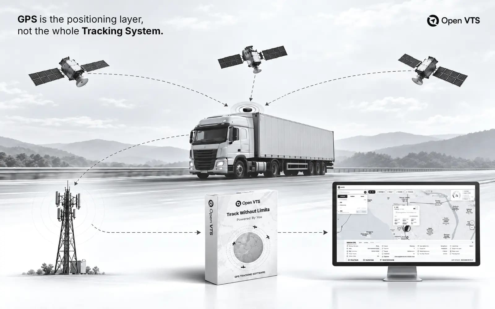
GPS tracking software is the software infrastructure that receives location and telemetry from tracking devices, processes and stores that information, and turns it into live maps, alerts, history, reports, APIs, and operational workflows.
GPS itself provides positioning. A complete vehicle-tracking system also requires a tracking device, connectivity, device protocols, server-side ingestion and decoding, storage, business logic, and user applications.
In one sentence: GPS provides the position; GPS tracking software turns position and device data into an operational system.
GPS Is the Positioning Layer, Not the Whole Tracking System
The Global Positioning System provides positioning, navigation, and timing services. Satellites broadcast one-way signals containing time and orbital information; a receiver uses signals from multiple satellites to calculate its position and time. That is the positioning layer—not the complete fleet-tracking stack.
A vehicle tracker takes that position and can combine it with other information supported by the hardware and installation: time, speed, heading, ignition state, power status, sensor values, and device events. It then sends structured records through a communications network to tracking infrastructure.
What happens after that transmission is what much of the category hides behind words such as “cloud” or “platform.” The server still has to accept the message, understand the device protocol, decode it, normalize it into a consistent data model, update the current vehicle state, retain history, apply rules, and deliver the result to users and connected systems.
The vehicle icon moving on a map is therefore the output of the tracking system—not the system itself.
The words software, platform, and system are often used interchangeably in this market, but they are not always identical. “Software” usually refers to the application and server capabilities; “platform” often implies a broader environment for users, devices, APIs, and integrations; “system” can describe the entire combination of hardware, connectivity, software, and operations. For this guide, GPS tracking software refers to the software/platform layer while recognizing that it operates inside a larger tracking system.
The 12 Layers Behind One Moving Vehicle Icon
A useful way to understand modern GPS tracking software is to follow the data through 12 layers. This is an Open VTS explanatory framework, not an industry standard.
1. Positioning
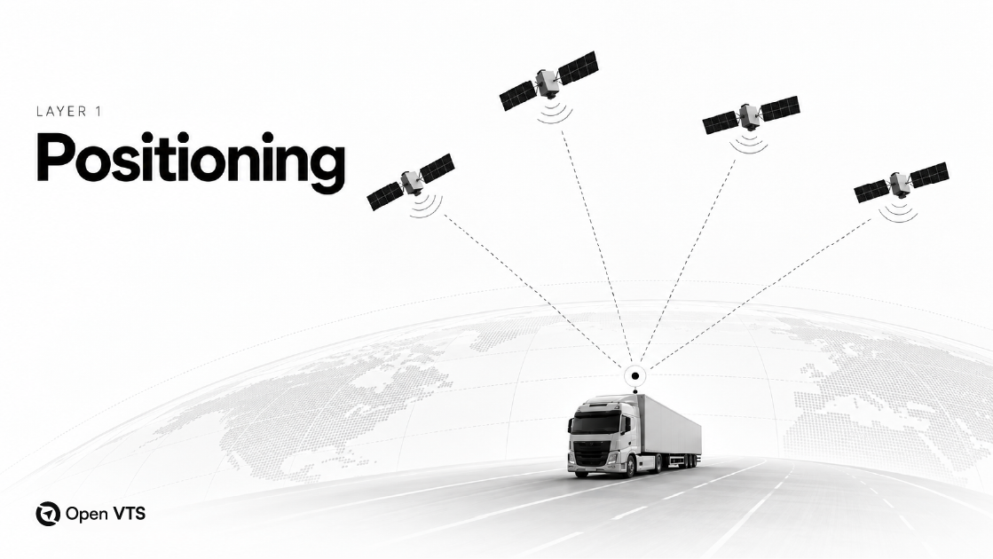
The tracker receives GPS/GNSS signals and calculates a position and time. GPS is one global navigation satellite system; modern devices may also support additional GNSS constellations. The positioning receiver establishes where the device is, but it does not create a fleet dashboard or transmit that information to a business application.
2. Tracker & Sensors
The physical device collects the position plus whatever additional information its hardware and installation support. That can include speed, heading, ignition, voltage, digital inputs, temperature, fuel-related sensor data, or other vehicle and asset information.
A platform can only use fields that the device can generate and that its protocol makes available.
3. Device Logic
Device firmware and configuration decide what to report and when. Reporting can be based on time, movement, ignition, distance, sensor conditions, or specific events.
This matters because software cannot display genuinely new information that the tracker never generated or transmitted. Device configuration is therefore part of the real tracking experience, even though it sits outside the web interface.
4. Connectivity
The tracker needs a communications path to the server. Cellular data is common in vehicle tracking, although other communication technologies can be used.
A loss of connectivity can delay remote visibility even when the device still knows its position. Depending on the tracker, records may be buffered locally and forwarded when the connection returns.
5. Transport & Device Protocol
The tracker sends data using a network transport such as TCP or UDP and a device-specific protocol that defines the packet structure. Public Teltonika documentation, for example, describes AVL data transmission over both TCP and UDP and multiple codec formats.
This is why configuring a tracker requires more than entering a server IP address. The receiving platform must also listen on the correct endpoint and understand the protocol the device speaks.
6. Listener / Ingestion
A server-side listener receives the connection or datagram on the appropriate endpoint. At this point, the platform has received data, but it may still be a manufacturer-specific binary or text packet that the rest of the application cannot use directly.
The ingestion layer also has to deal with realities such as reconnecting devices, malformed messages, duplicated records, and bursts of traffic without allowing those conditions to block unrelated devices.
7. Decode & Normalize
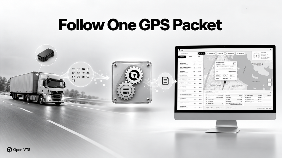
The decoder interprets the packet and extracts supported fields such as device identity, timestamp, latitude, longitude, speed, heading, events, and IO values. The platform then converts those protocol-specific fields into a consistent internal telemetry model.
Conceptually, the transformation looks like this:
raw device packet → protocol fields → normalized telemetry → platform state
Normalization is essential in a multi-device platform. Two trackers can encode the same concept in completely different ways, while maps, reports, alerts, and APIs need predictable fields.
8. Live State & Processing
The platform determines the latest known operational state of the vehicle: position, movement, ignition, connectivity, sensor status, and other current values needed by applications.
This layer is different from simply saving every message. Live applications need an efficient answer to the question, “What is the latest accepted state of this vehicle right now?”
9. Historical Storage
Telemetry and events are retained so the platform can reconstruct routes, trips, timelines, stops, distance, exceptions, and other historical views.
Current-state workloads and historical-analysis workloads are related, but they solve different problems. A live map needs the latest useful state quickly; a six-month report may need to search and aggregate a large history efficiently.
10. Events & Automation
Rules turn telemetry into action. A geofence crossing, overspeed condition, ignition change, or sensor threshold can create an event, notification, workflow, or another automated response.
Without this layer, tracking is mainly observational. With it, the system can respond to conditions as they occur.
11. APIs & Real-time Distribution
Processed information often needs to serve more than one interface. REST APIs, realtime sockets, event streams, and similar mechanisms can make tracking data available to web applications, mobile apps, customer portals, analytics, and external business systems.
This layer is particularly important when GPS tracking is part of a larger operation rather than a standalone dashboard.
12. User Applications
Only at the final layer does the user see the familiar outputs: live maps, vehicle details, replay, alerts, reports, dashboards, mobile applications, and integrations.
The map is the most visible layer. It is also the last one.
What Does GPS Tracking Software Actually Do?
Seen as a complete system, GPS tracking software performs several distinct jobs.
Live visibility maintains the latest known location and operational state. History and replay preserve previous movement so journeys and events can be reconstructed. Events and alerts convert conditions such as geofence entry, overspeeding, or ignition changes into actions. Reporting aggregates telemetry into information such as trips, distance, utilization, and exceptions.
The platform also has to manage operational entities—vehicles, devices, users, drivers, roles, configuration, and sometimes customers or subaccounts. Finally, APIs and realtime interfaces allow tracking information to participate in a larger business system rather than remaining trapped inside one dashboard.
Current GPS-software marketplace research repeatedly surfaces capabilities such as real-time monitoring, historical reporting, vehicle and asset tracking, geofencing, mobile access, permissions, and integrations.
The important point is that a live map is one capability inside a larger operational platform. A system becomes substantially more useful when current position, history, rules, users, reports, and integrations work from the same trusted telemetry pipeline.
What Features Matter in a Serious GPS Tracking Platform?
A useful evaluation starts with operating requirements, not the longest feature list.
Device compatibility comes first because the platform must correctly receive and interpret the trackers, sensors, and commands the business actually uses. Compatibility should be verified at device and protocol level; the same hardware brand can contain models that communicate differently.
Live-state handling matters because operators make decisions from the latest accepted device data. History and reporting matter because many operational questions concern what happened previously, not only what is happening now.
Events and automation reduce the need to watch a map continuously. Roles and permissions become important when multiple customers, teams, managers, or restricted users share the platform. APIs and realtime interfaces matter when GPS data must connect with ERP, dispatch, customer portals, mobile apps, analytics, or other software.
Finally, assess operational manageability. Production software eventually needs upgrades, backups, security controls, monitoring, troubleshooting, data-retention policies, and capacity planning.
More features do not automatically mean better software. The better question is whether the platform fits the organization’s devices, workflows, integrations, deployment requirements, and operating model.
Vendor-Hosted, Managed, or Self-Hosted: Where Does the Software Run?

Deployment is not simply a choice between “cloud” and “self-hosted.” Self-hosted software can itself run in AWS, Azure, Google Cloud, another hosting provider, or an organization’s own data center.
The more useful distinction is who operates and controls the application infrastructure.
With vendor-hosted SaaS, the software provider operates the platform and the customer consumes the service. This usually reduces the customer’s infrastructure responsibility, while customization, database access, retention, APIs, and other controls depend on the provider.
With a managed or private deployment, dedicated or customer-specific infrastructure may be used while a provider or partner handles some or all operations.
With self-hosted software, the organization deploys the platform on infrastructure it controls. That can provide more direct control over infrastructure, configuration, database access, retention, and customization. It also transfers more responsibility for security, backups, updates, monitoring, availability, and capacity.
Control and responsibility therefore move together.
None of these models is automatically superior. An organization seeking minimal infrastructure responsibility may prefer a vendor-hosted service. A business that values infrastructure control, direct access, deeper customization, or specific data-governance requirements may prefer self-hosting.
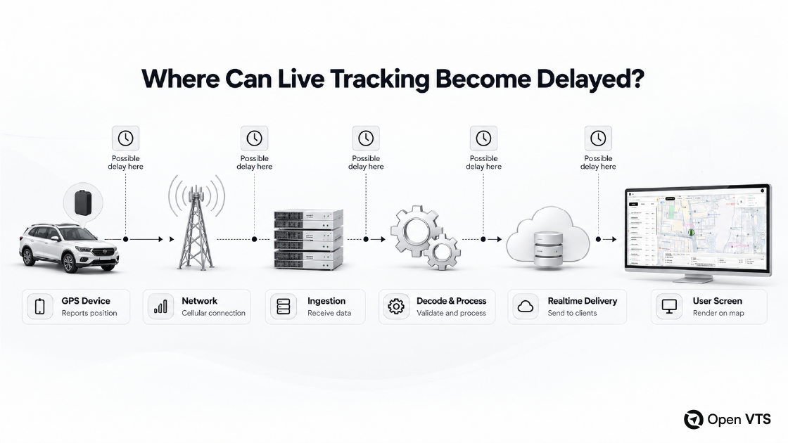
What Determines the Quality of “Real-Time” GPS Tracking?
“Real-time tracking” is often presented as a single feature, but the experience depends on the entire data path.
A useful model is:
device reporting + positioning quality + network availability + ingestion + decoding + processing + real-time delivery + interface rendering = perceived tracking freshness
If a tracker reports once every 60 seconds, the platform cannot produce genuine one-second position updates from data it did not receive. If the tracker has a valid position but temporarily loses network connectivity, the remote platform cannot show that new record until communication resumes. Some devices can buffer records and transmit them later, depending on hardware, protocol, memory, and configuration.
Delayed telemetry creates another important distinction: event time is not necessarily receive time. A record generated earlier and delivered after connectivity returns should remain part of the historical sequence without being mistaken for a brand-new current position. How a platform handles late, duplicate, or out-of-order telemetry therefore affects both live accuracy and historical integrity.
Server-side design matters too. A new message still has to be accepted, decoded, processed, persisted where necessary, and delivered to applications.
So instead of asking only, “Does this platform support real-time tracking?” ask how frequently devices report, what happens during connectivity loss, how delayed records are handled, how quickly telemetry is processed, and how current state reaches web and mobile users.
Real-time quality is an end-to-end property.
How Should a Business Evaluate GPS Tracking Software?
Before comparing products, define what the system must accomplish.
| Dimension | Question to ask |
|---|---|
| Hardware | Does the platform support the trackers, protocols, sensors, and commands you actually use? |
| Functionality | Does it support the workflows your operation depends on? |
| Realtime quality | How fresh and reliable is data from device to screen? |
| Integration | Are APIs and realtime interfaces sufficient for other systems? |
| Deployment | Who should operate the application infrastructure? |
| Control | Who controls configuration, database access, retention, and infrastructure? |
| Economics | What is the total cost over the period you expect to operate the system? |
| Operations | Who handles security, updates, backups, monitoring, scaling, and support? |
This prevents a common buying mistake: evaluating GPS software mainly from screenshots or headline feature counts.
A polished map can still be the wrong platform if it cannot communicate with required hardware, expose the necessary integrations, preserve the right history, or operate under the required deployment model. Conversely, a highly customizable self-hosted system can be the wrong fit for an organization that does not want to operate software infrastructure.
Before buying, it is also worth testing the actual path that matters to your business: connect representative devices, verify the telemetry fields you need, trigger important events, generate reports, test API access, and observe how the platform behaves when a device loses connectivity. A short realistic pilot can reveal gaps that a feature checklist cannot.
A serious evaluation therefore considers both software capability and operational responsibility.
What Does GPS Tracking Software Cost?
Software price is only one component of tracking economics.
A more useful total-cost model is:
hardware + connectivity + software + infrastructure + installation + integration + support + operations
Depending on the implementation, costs can also include mapping/geocoding services, backups, monitoring, data transfer, mobile applications, or custom integrations.
Different deployment models distribute those costs differently. Hosted services may bundle infrastructure and some operating responsibility into recurring fees. Self-hosted systems may separate software licensing from infrastructure, administration, support, and internal operating costs.
Fleet size, reporting frequency, data retention, device type, integration complexity, and support expectations can all affect the total.
The better question is not “Which license is cheapest?” but “What will the complete tracking system cost under our actual requirements?”
Where Open VTS Fits in This Architecture
Open VTS is one implementation of the architecture described above. It is designed for self-hosted deployment on infrastructure controlled by the customer, including the customer’s own cloud or server environment. Its current pricing page explicitly lists self-hosted deployment across its plans.
Verified on September 23, 2026, the public Open VTS compatibility database lists 1,639+ devices across 260+ protocols and 269+ brands. These are dynamic first-party platform figures rather than permanent industry statistics.
The current Open VTS API reference documents 426 endpoints across authentication, platform administration, fleet administration, user operations, and health interfaces. It also documents Server-Sent Events and Socket.IO for streaming and realtime use cases.
Want to see the complete stack in a real platform?
Explore Open VTS. The current Free plan supports up to 50 vehicles on a self-hosted deployment.
Frequently Asked Questions
Is GPS tracking software the same as a GPS tracker?
No. A GPS tracker is the physical device that determines location and collects supported telemetry. GPS tracking software receives and interprets that information, stores it, applies business logic, and makes the result usable through maps, history, alerts, reports, APIs, and other applications.
Does GPS tracking software work without the internet?
The GPS/GNSS receiver does not need internet access to calculate its position from satellite signals. Remote tracking still requires a communications path between the device and platform. Some trackers can store records while connectivity is unavailable and transmit them later, depending on the device and configuration.
Can different GPS tracker brands use the same software?
Yes, when the software supports the relevant devices and protocols. Manufacturers can use different packet structures, commands, sensor mappings, and connection behavior, so compatibility needs to be implemented and verified rather than assumed from the word “GPS.”
Is GPS tracking software always vendor-hosted?
No. A platform may be delivered as vendor-hosted SaaS, a managed/private deployment, or self-hosted software. Self-hosted software can run on-premises or inside a customer-controlled public-cloud account.
The Map Is Only the Last Layer
A moving vehicle icon may look simple, but behind it is a chain of positioning, hardware, connectivity, protocols, ingestion, decoding, live-state processing, storage, events, realtime distribution, and applications.
Understanding those layers changes how GPS tracking software should be evaluated. Instead of choosing by the map or feature count alone, businesses can examine device compatibility, architecture, integrations, deployment, economics, and operational responsibility.


